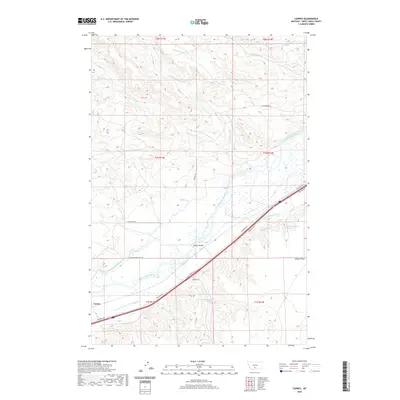
2020 Map of Carney
USGS Topo · Published 2020About this map
The Yellowstone River cuts through the heart of this landscape in Sweet Grass County, defining the valley's complex network of irrigation and transport. A sophisticated system of water management is visible through labels like the Post-Kellogg Ditch, Prather Mayborn Westfall Ditch, and the Hunters Hot Springs Canal, illustrating how the arid surroundings were adapted for agriculture and ranching. Near the settlement of Carney, the infrastructure follows the river's path, with the N Yellowstone Trail Rd and Vogues Bridge marking historical transit corridors. To the north, the terrain is deeply dissected by numerous tributaries including Little Timber Cr and Featherbed Cr, while the southeast is characterized by the broad level of Airport Flats. This modern survey reveals a landscape where old ranching routes like Cow Creek Rd and Dugout Rd interface with the primary arterial flow of the river valley.
Find a feature on this map
35 named features on this map. Tap any name to fly to it.
Don’t see what you’re looking for? This feature index may not catch every label — zoom into the map to look around manually.
Map Details
Editions of this 2020 Carney Map
This is the sole edition of this map. No revisions or reprints were ever made.
Other maps of this area

1891 · Livingston
USGS Topo · 1:250,000

1891 · Big Timber
USGS Topo · 1:125,000

1893 · Livingston
USGS Topo · 1:250,000

1893 · Big Timber
USGS Topo · 1:125,000

1947 · Bozeman
USGS Topo · 1:250,000

1948 · Bozeman
USGS Topo · 1:250,000
1951 · Grosfield Ranch
USGS Topo · 1:24,000
1951 · Raspberry Butte
USGS Topo · 1:24,000

1951 · Kelly Hills
USGS Topo · 1:24,000

1951 · Springdale
USGS Topo · 1:24,000