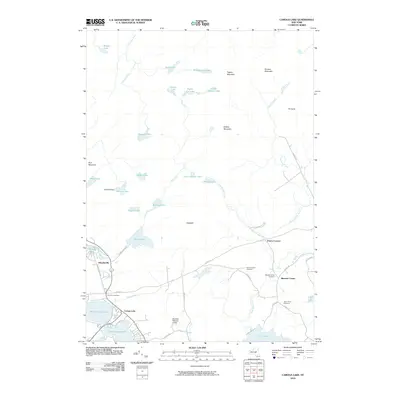
2010 Map of Caroga Lake
USGS Topo · Published 2010About this map
Caroga Lake and its sister bodies of water, East Caroga Lake and West Caroga Lake, anchor the southern half of this landscape in the southern Adirondack region. The settlement pattern here is defined by clusters of seasonal and year-round homes connected by routes like London Bridge Rd and Garlock Rd. To the east, the rural character of Bleecker Center is marked by a concentration of local history markers, including Bleecker Center Cemetery, Saint Josephs Cemetery, and Saint Johns Cemetery.
Find a feature on this map
54 named features on this map. Tap any name to fly to it.
Don’t see what you’re looking for? This feature index may not catch every label — zoom into the map to look around manually.
Map Details
Editions of this 2010 Caroga Lake Map
This is the sole edition of this map. No revisions or reprints were ever made.
Other maps of this area

1901 · Lassellsville
USGS Topo · 1:62,500

1903 · Gloversville
USGS Topo · 1:62,500

1903 · Lassellsville
USGS Topo · 1:62,500

1904 · Piseco Lake
USGS Topo · 1:62,500

1906 · Piseco Lake
USGS Topo · 1:62,500

1907 · Lake Pleasant
USGS Topo · 1:62,500

1908 · Piseco Lake
USGS Topo · 1:62,500

1943 · Gloversville
USGS Topo · 1:62,500

1945 · Caroga Lake
USGS Topo · 1:24,000
1945 · Canada Lake
USGS Topo · 1:24,000