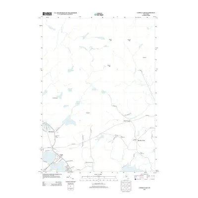
2013 Map of Caroga Lake
USGS Topo · Published 2013About this map
Caroga Lake serves as a primary hub for this Adirondack landscape, where seasonal recreation and permanent settlements meet. The area is defined by a dense network of water bodies, including Peck Lake, Irving Pond, and the expansive Holmes Lake, which feeds into the Holmes Lake Outlet. Small communities like Wheelerville and Bleecker Center are interconnected by a web of local roads such as Co HWY-112 and Persch RD, reflecting a long history of timber and transit in Fulton County.
Find a feature on this map
74 named features on this map. Tap any name to fly to it.
Don’t see what you’re looking for? This feature index may not catch every label — zoom into the map to look around manually.
Map Details
Editions of this 2013 Caroga Lake Map
This is the sole edition of this map. No revisions or reprints were ever made.
Other maps of this area

1901 · Lassellsville
USGS Topo · 1:62,500

1903 · Gloversville
USGS Topo · 1:62,500

1903 · Lassellsville
USGS Topo · 1:62,500

1904 · Piseco Lake
USGS Topo · 1:62,500

1906 · Piseco Lake
USGS Topo · 1:62,500

1907 · Lake Pleasant
USGS Topo · 1:62,500

1908 · Piseco Lake
USGS Topo · 1:62,500

1943 · Gloversville
USGS Topo · 1:62,500

1945 · Caroga Lake
USGS Topo · 1:24,000
1945 · Canada Lake
USGS Topo · 1:24,000