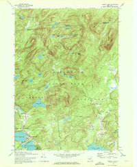
1970 Map of Caroga Lake
USGS Topo · Published 1972About this map
Adirondack State Park dominates this landscape, characterized by a dense concentration of glacial lakes and prominent peaks in the southern Adirondacks. The settlement of Caroga Lake serves as a central hub between West Caroga Lake and East Caroga Lake, while smaller hamlets like Wheelerville and Bleecker Center dot the surrounding highlands. This 1970 revision captures the region's character as a recreational destination, featuring the Mohawk Pathway Camp and a local Golf Course. For genealogists and local historians, the presence of St Josephs Cem, St Johns Cem, and St Barbaras Chapel provides specific markers of early community life. The northern half of the map remains largely wild, punctuated by remote water bodies such as Duck Lake and County Line Lake, along with elevations like Panther Mtn and Pigeon Mtn that define the boundary between Arietta and Benson.
Find a feature on this map
61 named features on this map. Tap any name to fly to it.
Don’t see what you’re looking for? This feature index may not catch every label — zoom into the map to look around manually.
Map Details
Editions of this 1970 Caroga Lake Map
This is the sole edition of this map. No revisions or reprints were ever made.
Other maps of this area

1901 · Lassellsville
USGS Topo · 1:62,500

1903 · Gloversville
USGS Topo · 1:62,500

1903 · Lassellsville
USGS Topo · 1:62,500

1904 · Piseco Lake
USGS Topo · 1:62,500

1906 · Piseco Lake
USGS Topo · 1:62,500

1907 · Lake Pleasant
USGS Topo · 1:62,500

1908 · Piseco Lake
USGS Topo · 1:62,500

1943 · Gloversville
USGS Topo · 1:62,500

1945 · Caroga Lake
USGS Topo · 1:24,000
1945 · Canada Lake
USGS Topo · 1:24,000