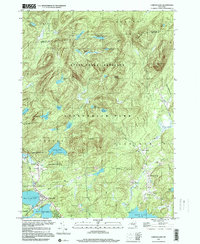
1997 Map of Caroga Lake
USGS Topo · Published 2000About this map
The Southern Adirondack wilderness meets rural mountain settlements in this late 20th-century survey of the Caroga Bleecker area. Densely packed contour lines define the numerous summits of the Adirondack Park, including Shaker Mtn and Pigeon Mtn, which surround a high concentration of water bodies. The landscape transitions from the protected State Forest Preserve in the north to established communities in the south, centered around the interconnected waters of West Caroga Lake, Caroga Lake, and East Caroga Lake.
Find a feature on this map
58 named features on this map. Tap any name to fly to it.
Don’t see what you’re looking for? This feature index may not catch every label — zoom into the map to look around manually.
Map Details
Editions of this 1997 Caroga Lake Map
This is the sole edition of this map. No revisions or reprints were ever made.
Other maps of this area

1901 · Lassellsville
USGS Topo · 1:62,500

1903 · Gloversville
USGS Topo · 1:62,500

1903 · Lassellsville
USGS Topo · 1:62,500

1904 · Piseco Lake
USGS Topo · 1:62,500

1906 · Piseco Lake
USGS Topo · 1:62,500

1907 · Lake Pleasant
USGS Topo · 1:62,500

1908 · Piseco Lake
USGS Topo · 1:62,500

1943 · Gloversville
USGS Topo · 1:62,500

1945 · Caroga Lake
USGS Topo · 1:24,000
1945 · Canada Lake
USGS Topo · 1:24,000