
1940 Map of Carolina
USGS Topo · Published 1940About this map
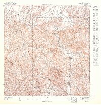
Carolina and the surrounding coastal plains of northeast Puerto Rico are depicted here shortly before the mid-century industrial shift. The landscape is defined by the winding Rio Grande de Loiza and a series of sugar-producing agricultural colonies, including Colonia Monserrate, Colonia Virginia, and Colonia Las Mercedes. Industrial hubs like Central Victoria and Central Canovanas highlight the era's economic reliance on the sugar trade, while the presence of the Segunda Unidad de San Anton school suggests the development of local civic infrastructure.
Find a feature on this map
55 named features on this map. Tap any name to fly to it.
Don’t see what you’re looking for? This feature index may not catch every label — zoom into the map to look around manually.
Map Details
Editions of this 1940 Carolina Map
This is the sole edition of this map. No revisions or reprints were ever made.
Other maps of this area

1941 · San Juan
USGS Topo · 1:30,000

1941 · Rio Grande
USGS Topo · 1:30,000

1941 · Carolina
USGS Topo · 1:30,000

1945 · El Yunque
USGS Topo · 1:30,000

1946 · El Yunque
USGS Topo · 1:30,000

1946 · Aguas Buenas
USGS Topo · 1:30,000

1946 · Gurabo
USGS Topo · 1:30,000

1947 · Carolina
USGS Topo · 1:30,000
1947 · Gurabo NE
USGS Topo · 1:10,000

1947 · Rio Grande
USGS Topo · 1:30,000