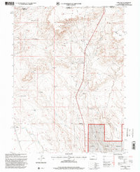
1997 Map of Carr East
USGS Topo · Published 2000About this map
The high plains of the Wyoming-Colorado border define this landscape, where early ranching and railroad infrastructure shaped the development of northern Weld County. Scattered family-named landmarks like Davis Windmill, Schnoor Windmill, and Shaklee Windmill reveal a pattern of persistent water management essential for livestock in this arid environment. The small settlements of Carr and Rockport serve as anchors along the transport corridor, while the southern portion of the sheet is dominated by the protected expanse of the Pawnee National Grassland. Drainage patterns from Lone Tree Creek and Owl Creek carve through the terrain, leading toward the prominent elevation of Simpson Mesa in the northeast. This 1990s revision provides a clear record of the intersection between industrial pipelines, historic campsites like Baxter Camp, and the enduring agricultural footprint of the region.
Find a feature on this map
20 named features on this map. Tap any name to fly to it.
Don’t see what you’re looking for? This feature index may not catch every label — zoom into the map to look around manually.
Map Details
Editions of this 1997 Carr East Map
This is the sole edition of this map. No revisions or reprints were ever made.
Other maps of this area

1908 · Eaton
USGS Topo · 1:125,000

1910 · Eaton
USGS Topo · 1:125,000

1911 · Cheyenne
USGS Topo · 1:125,000

1914 · Cheyenne
USGS Topo · 1:125,000

1950 · Cheyenne
USGS Topo · 1:62,500

1954 · Cheyenne
USGS Topo · 1:250,000

1954 · Greeley
USGS Topo · 1:250,000

1957 · Greeley
USGS Topo · 1:250,000

1958 · Cheyenne
USGS Topo · 1:250,000

1958 · Greeley
USGS Topo · 1:250,000