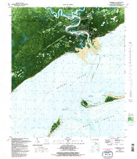
1981 Map of Carrabelle
USGS Topo · Published 1992About this map
The coastal town of Carrabelle and the surrounding maritime landscape of Franklin County are meticulously documented in this orthophotomap, which utilizes 1970s aerial photography to show the shifting sands and dense wetlands of the Florida Panhandle. The meeting of the Carrabelle River and Crooked River creates a complex delta system featuring Teal Miller Flats and Davis Island. Notable landmarks marking the interface between land and sea include the Crooked River Lighthouse and the Carrabelle Lookout Tower. In St George Sound, the map details a massive Dog Island and various shoals such as Cannonball Point, with bathymetric data indicating an area subject to frequent change near East Pass. Human presence is evidenced by the US Air Force Tracking Station, the Carrabelle Flight Strip, and local infrastructure like the Carrabelle High Sch.
Find a feature on this map
38 named features on this map. Tap any name to fly to it.
Don’t see what you’re looking for? This feature index may not catch every label — zoom into the map to look around manually.
Map Details
Editions of this 1981 Carrabelle Map
4 editions found
Other maps of this area

1943 · Dog Island
USGS Topo · 1:31,680

1943 · Carrabelle
USGS Topo · 1:24,000

1944 · Pickett Bay
USGS Topo · 1:31,680

1944 · Carrabelle
USGS Topo · 1:31,680

1944 · Green Point
USGS Topo · 1:31,680

1944 · Sugar Hill
USGS Topo · 1:31,680

1945 · Tates Hell Swamp
USGS Topo · 1:31,680

1945 · Mc Intyre
USGS Topo · 1:31,680

1945 · Sugar Hill
USGS Topo · 1:31,680

1945 · Pickett Bay
USGS Topo · 1:31,680