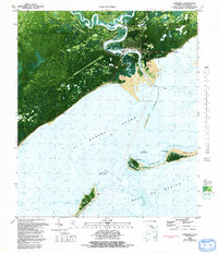
1981 Map of Carrabelle
USGS Topo · Published 1992About this map
The confluence of the Carrabelle River, Crooked River, and New River shapes this coastal landscape, where the town of Carrabelle serves as a gateway to the Gulf of Mexico. This orthophotomap provides a clear view of the mid-20th-century coastal infrastructure, including the Carrabelle Flight Strip and a U S Air Force Tracking Station. To the east, St James Island contains numerous small water bodies like Lake Morality and Chason Ponds, while the formidable Hell Gates Swamp dominates the northwestern interior. The map illustrates the shifting nature of the Florida Panhandle shoreline, noting areas subject to frequent change near East Pass and the barrier dunes of Dog Island. Maritime history is evident through the Crooked River Lighthouse and the Carrabelle Lookout Tower, which guarded these vital Florida waterways.
Find a feature on this map
38 named features on this map. Tap any name to fly to it.
Don’t see what you’re looking for? This feature index may not catch every label — zoom into the map to look around manually.
Map Details
Editions of this 1981 Carrabelle Map
4 editions found
Other maps of this area

1943 · Dog Island
USGS Topo · 1:31,680

1943 · Carrabelle
USGS Topo · 1:24,000

1944 · Pickett Bay
USGS Topo · 1:31,680

1944 · Carrabelle
USGS Topo · 1:31,680

1944 · Green Point
USGS Topo · 1:31,680

1944 · Sugar Hill
USGS Topo · 1:31,680

1945 · Tates Hell Swamp
USGS Topo · 1:31,680

1945 · Mc Intyre
USGS Topo · 1:31,680

1945 · Sugar Hill
USGS Topo · 1:31,680

1945 · Pickett Bay
USGS Topo · 1:31,680