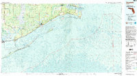
1978 Map of Carrabelle
USGS Topo · Published 1985About this map
Tates Hell Swamp dominates the western interior of this coastal landscape, a massive wetland area bordering the Apalachicola National Forest. Along the Gulf of Mexico, the map reveals a complex system of barrier islands and shoals, including the lengthy St George Island and Dog Island, which shelter the waters of St George Sound. The settlement of Carrabelle sits at the junction of the Crooked River and Carrabelle River, serving as a gateway to the fishing and maritime activities of Apalachicola Bay.
Find a feature on this map
65 named features on this map. Tap any name to fly to it.
Don’t see what you’re looking for? This feature index may not catch every label — zoom into the map to look around manually.
Map Details
Editions of this 1978 Carrabelle Map
4 editions found
Other maps of this area

1940 · Arran
USGS Topo · 1:62,500

1943 · Arran
USGS Topo · 1:62,500

1943 · Dog Island
USGS Topo · 1:31,680

1943 · West Pass
USGS Topo · 1:31,680

1943 · Apalachicola
USGS Topo · 1:31,680

1943 · Carrabelle
USGS Topo · 1:24,000

1943 · St. Teresa Beach
USGS Topo · 1:24,000

1943 · Jackson River
USGS Topo · 1:24,000

1943 · Lighthouse Point
USGS Topo · 1:24,000

1944 · Pickett Bay
USGS Topo · 1:31,680