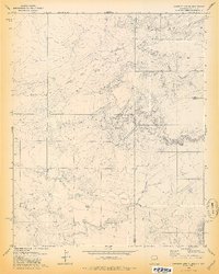
1978 Map of Carrisito Spring
USGS Topo · Published 1978About this map
Carrisito Spring sits at the heart of this high-desert landscape, where the borders of Arizona and New Mexico converge. This 1970s survey captures a transition point between Apache County and Catron County, defined by a series of dramatic canyons and ephemeral watercourses. The drainage patterns of Little Blanco Canyon and Blanco Canyon dictate the local topography, carving paths through the plateau alongside Twentytwo Draw and Carrizo Wash. Human infrastructure is sparse, limited to utilitarian features necessary for livestock and travel across the arid terrain. Mapping identifies several corrals, a Water Tank, and a Well, connected by a winding Jeep Trail. These elements, along with Horse Can, provide a clear picture of the remote grazing and ranching life characteristic of the Four Corners region in the late twentieth century.
Find a feature on this map
18 named features on this map. Tap any name to fly to it.
Don’t see what you’re looking for? This feature index may not catch every label — zoom into the map to look around manually.
Map Details
Editions of this 1978 Carrisito Spring Map
2 editions found
Other maps of this area

1886 · St Johns
USGS Topo · 1:250,000

1892 · St Johns
USGS Topo · 1:250,000

1954 · Saint Johns
USGS Topo · 1:250,000

1957 · Saint Johns
USGS Topo · 1:250,000

1958 · Saint Johns
USGS Topo · 1:250,000

1962 · Saint Johns
USGS Topo · 1:250,000

1971 · Mesa Parada NW
USGS Topo · 1:24,000

1971 · Mesa Parada
USGS Topo · 1:24,000

1972 · Twentytwo Spring
USGS Topo · 1:24,000

1972 · Cantaralo Spring
USGS Topo · 1:24,000