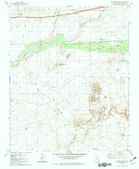
1982 Map of Carrizo Butte
USGS Topo · Published 1983About this map
Goodwater serves as a primary reference point in this arid Navajo County landscape, where the Puerco River and numerous washes like Lithodendron Wash carve through the high desert. The transportation corridor is dominated by the Atchison Topeka and Santa Fe Railroad, which runs parallel to the Old Atchison Topeka and Santa Fe Railroad Grades, revealing the evolving path of the rail line through the territory.
Find a feature on this map
30 named features on this map. Tap any name to fly to it.
Don’t see what you’re looking for? This feature index may not catch every label — zoom into the map to look around manually.
Map Details
Editions of this 1982 Carrizo Butte Map
This is the sole edition of this map. No revisions or reprints were ever made.
Other maps of this area

1883 · Tusayan
USGS Topo · 1:250,000

1886 · St Johns
USGS Topo · 1:250,000

1886 · Tusayan
USGS Topo · 1:250,000

1886 · Fort Defiance
USGS Topo · 1:250,000

1886 · Holbrook
USGS Topo · 1:250,000

1892 · Fort Defiance
USGS Topo · 1:250,000

1892 · St Johns
USGS Topo · 1:250,000

1893 · Holbrook
USGS Topo · 1:250,000

1912 · Petrified Forest
USGS Topo · 1:62,500

1947 · Flagstaff
USGS Topo · 1:250,000