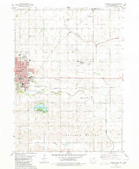
1980 Map of Carroll East
USGS Topo · Published 1980About this map
Carroll serves as the focal point of this west-central Iowa survey, which documents the expansion of the community and the surrounding agricultural townships of Grant, Sheridan, and Pleasant Valley. The landscape is defined by the winding course of the Middle Raccoon River and the Maple River, while the Chicago and North Western railroad line bisects the territory, illustrating the area's historical reliance on rail transport for its farming economy. To the south, the recreational grounds of Swan Lake State Park provide a distinct contrast to the grid of rural section lines.
Find a feature on this map
37 named features on this map. Tap any name to fly to it.
Don’t see what you’re looking for? This feature index may not catch every label — zoom into the map to look around manually.
Map Details
Editions of this 1980 Carroll East Map
This is the sole edition of this map. No revisions or reprints were ever made.
Other maps of this area

1954 · Omaha
USGS Topo · 1:250,000

1954 · Fort Dodge
USGS Topo · 1:250,000

1957 · Omaha
USGS Topo · 1:250,000

1957 · Fort Dodge
USGS Topo · 1:250,000

1958 · Omaha
USGS Topo · 1:250,000

1958 · Fort Dodge
USGS Topo · 1:250,000

1971 · Dedham
USGS Topo · 1:24,000

1971 · Coon Rapids North
USGS Topo · 1:24,000

1971 · Templeton
USGS Topo · 1:24,000
1980 · Glidden
USGS Topo · 1:24,000