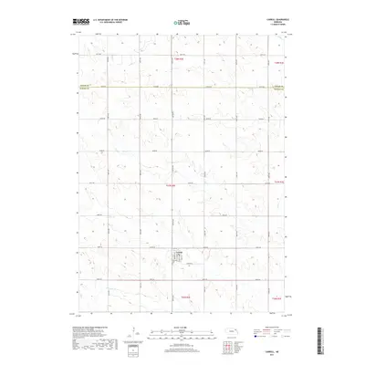
2017 Map of Carroll
USGS Topo · Published 2017About this map
The village of Carroll serves as the central hub of this agricultural landscape in northeastern Nebraska, situated near the boundary between Cedar Co and Wayne Co. The settlement is laid out on a traditional grid, featuring streets such as Pierce St, Main St, and Court St. On the southern edge of the community, Elmwood Cem provides a primary point of interest for genealogists and local historians documenting the region's heritage. The surrounding terrain is defined by a dendritic drainage pattern, with the waters of Dog Cr, Deer Cr, and Baker Cr carving through the prairie. A meticulously surveyed section-line road network, including 864th Rd and 567th Ave, connects the outlying farmsteads to the village center, illustrating the enduring influence of the Public Land Survey System on the state's modern geography.
Find a feature on this map
32 named features on this map. Tap any name to fly to it.
Don’t see what you’re looking for? This feature index may not catch every label — zoom into the map to look around manually.
Map Details
Editions of this 2017 Carroll Map
This is the sole edition of this map. No revisions or reprints were ever made.
Other maps of this area

1955 · Sioux City
USGS Topo · 1:250,000

1958 · Sioux City
USGS Topo · 1:250,000

1959 · Sioux City
USGS Topo · 1:250,000

1963 · Winside
USGS Topo · 1:24,000

1963 · Norfolk NE
USGS Topo · 1:24,000

1963 · Wayne
USGS Topo · 1:24,000
1971 · Laurel
USGS Topo · 1:24,000

1971 · Belden
USGS Topo · 1:24,000

1971 · Randolph South
USGS Topo · 1:24,000

1971 · Randolph North
USGS Topo · 1:24,000