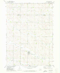
1971 Map of Carroll
USGS Topo · Published 1973About this map
Carroll stands as the primary hub of this northern Nebraska landscape, situated near the southern border of Wayne County. The town is marked by a grid of streets and key community sites including Elmwood Cem and nearby Sewage Disposal Ponds. One of the most striking historical features is the Old Deer Railroad Grade, which angles across the southern half of the township. This former rail line once followed the natural drainage of Old Deer Railroad Grade Creek, indicating a legacy of early transport that prioritized river-valley routes.
Find a feature on this map
11 named features on this map. Tap any name to fly to it.
Don’t see what you’re looking for? This feature index may not catch every label — zoom into the map to look around manually.
Map Details
Editions of this 1971 Carroll Map
This is the sole edition of this map. No revisions or reprints were ever made.
Other maps of this area

1955 · Sioux City
USGS Topo · 1:250,000

1958 · Sioux City
USGS Topo · 1:250,000

1959 · Sioux City
USGS Topo · 1:250,000

1963 · Winside
USGS Topo · 1:24,000

1963 · Norfolk NE
USGS Topo · 1:24,000

1963 · Wayne
USGS Topo · 1:24,000
1971 · Laurel
USGS Topo · 1:24,000

1971 · Belden
USGS Topo · 1:24,000

1971 · Randolph South
USGS Topo · 1:24,000

1971 · Randolph North
USGS Topo · 1:24,000