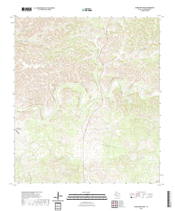
2022 Map of Carruthers Draw
USGS Topo · Published 2022About this map
Carruthers Draw and the surrounding high desert of Val Verde County characterize this modern topographic survey, defined by a complex network of seasonal drainages that carve through the limestone plateau. The landscape is primarily shaped by water movement during infrequent storms, with features like Miers Draw and Cedar Draw channeling runoff toward the regional basins. Human infrastructure in this arid environment is sparse and oriented toward ranching and aviation. The Morning Star Ranch Airport serves as a critical navigation point for this remote territory, while a network of unpaved tracks, including Dolan Creek Rd and Miers Ranch Rd, provides the only overland access across the deeply etched terrain. The course of Red Bluff Cr meanders through the central portion of the sheet, illustrating the typical intermittent hydrology of the West Texas borderlands.
Find a feature on this map
9 named features on this map. Tap any name to fly to it.
Don’t see what you’re looking for? This feature index may not catch every label — zoom into the map to look around manually.
Map Details
Editions of this 2022 Carruthers Draw Map
This is the sole edition of this map. No revisions or reprints were ever made.
Other maps of this area

1943 · Carta Valley
USGS Topo · 1:62,500

1944 · Flat Rock
USGS Topo · 1:62,500

1944 · Dry Devil
USGS Topo · 1:62,500

1944 · Devils Lake
USGS Topo · 1:62,500

1958 · Del Rio
USGS Topo · 1:250,000

1964 · Del Rio
USGS Topo · 1:250,000

1972 · Miers Ranch
USGS Topo · 1:24,000
1972 · Satan Canyon
USGS Topo · 1:24,000
1978 · Holcomb Draw
USGS Topo · 1:24,000
1978 · Open Hollow
USGS Topo · 1:24,000