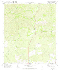
1979 Map of Carruthers Draw
USGS Topo · Published 1979About this map
Carruthers Draw and its many tributary drainage systems dominate this West Texas landscape in Val Verde County as recorded in the late 1970s. The topography is defined by the complex erosion patterns of the Edwards Plateau, where ephemeral watercourses like Cedar Draw, Piñon Draw, and Old Ranch Draw converge. A notable human landmark in this ranching country is the Rodeo Ground located near the banks of Miers Draw. The elevation drops toward the southern reaches of the map, marked by the prominent Red Bluff and the winding path of Red Bluff Creek. This survey, compiled from 1974 aerial photography by the Texas Department of Water Resources and federal agencies, details a network of unimproved roads and fence lines that illustrate the remote nature of these late-twentieth-century cattle and sheep ranching operations.
Find a feature on this map
9 named features on this map. Tap any name to fly to it.
Don’t see what you’re looking for? This feature index may not catch every label — zoom into the map to look around manually.
Map Details
Editions of this 1979 Carruthers Draw Map
This is the sole edition of this map. No revisions or reprints were ever made.
Other maps of this area

1943 · Carta Valley
USGS Topo · 1:62,500

1944 · Flat Rock
USGS Topo · 1:62,500

1944 · Dry Devil
USGS Topo · 1:62,500

1944 · Devils Lake
USGS Topo · 1:62,500

1958 · Del Rio
USGS Topo · 1:250,000

1964 · Del Rio
USGS Topo · 1:250,000

1972 · Miers Ranch
USGS Topo · 1:24,000
1972 · Satan Canyon
USGS Topo · 1:24,000
1978 · Holcomb Draw
USGS Topo · 1:24,000
1978 · Open Hollow
USGS Topo · 1:24,000