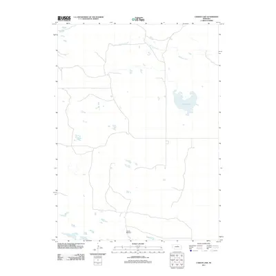
2011 Map of Carson Lake
USGS Topo · Published 2011About this map
Carson Lake and the winding course of Big Cedar Creek define this rural landscape in Holt County, Nebraska. This 2011 survey illustrates a region dominated by wide-open spaces and the intricate water systems of the Nebraska Sandhills. In the southern portion of the sheet, the flat terrain gives way to Garska Meadow, a feature that highlights the local importance of named landforms in this agricultural and pastoral environment. The network of local roads and unimproved trails provides a clear look at the sparse settlement patterns and the way infrastructure adapts to the natural contours of the creeks and wetlands.
Find a feature on this map
3 named features on this map. Tap any name to fly to it.
Don’t see what you’re looking for? This feature index may not catch every label — zoom into the map to look around manually.
Map Details
Editions of this 2011 Carson Lake Map
This is the sole edition of this map. No revisions or reprints were ever made.
Other maps of this area

1952 · Burwell NE
USGS Topo · 1:24,000

1952 · Burwell NW
USGS Topo · 1:24,000

1952 · Taylor NE
USGS Topo · 1:24,000

1955 · Broken Bow
USGS Topo · 1:250,000

1955 · O'Neill
USGS Topo · 1:250,000

1956 · Broken Bow
USGS Topo · 1:250,000

1959 · O'Neill
USGS Topo · 1:250,000

1969 · O'Neill
USGS Topo · 1:250,000
1981 · Abbott Ranch
USGS Topo · 1:24,000

1981 · Swan Lake
USGS Topo · 1:24,000