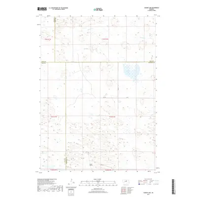
2017 Map of Carson Lake
USGS Topo · Published 2017About this map
Carson Lake and the surrounding Nebraska Sandhills are the primary features of this landscape at the intersection of four counties. The terrain is defined by a sparse network of section-line roads, including 846th Rd and 840th Rd, which navigate the depressions between stable sand dunes. Water is the most significant indicator of the local ecology here, with the intermittent flow of Big Cedar Cr and the presence of Garska Meadow suggesting a high water table and sensitive grassland environment.
Find a feature on this map
17 named features on this map. Tap any name to fly to it.
Don’t see what you’re looking for? This feature index may not catch every label — zoom into the map to look around manually.
Map Details
Editions of this 2017 Carson Lake Map
This is the sole edition of this map. No revisions or reprints were ever made.
Other maps of this area

1952 · Burwell NE
USGS Topo · 1:24,000

1952 · Burwell NW
USGS Topo · 1:24,000

1952 · Taylor NE
USGS Topo · 1:24,000

1955 · Broken Bow
USGS Topo · 1:250,000

1955 · O'Neill
USGS Topo · 1:250,000

1956 · Broken Bow
USGS Topo · 1:250,000

1959 · O'Neill
USGS Topo · 1:250,000

1969 · O'Neill
USGS Topo · 1:250,000
1981 · Abbott Ranch
USGS Topo · 1:24,000

1981 · Swan Lake
USGS Topo · 1:24,000