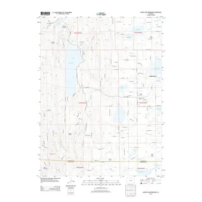
2013 Map of Carter Lake Reservoir
USGS Topo · Published 2013About this map
Carter Lake Reservoir dominates this landscape along the eastern edge of the Front Range, illustrating a sophisticated network of water management as the foothills meet the plains. The western half is defined by the steep relief of Flatiron Mountain and the secluded Chimney Hollow, while the eastern side transitions into the irrigated agricultural lands surrounding Berthoud. This 2013 survey provides a detailed look at the infrastructure of the Colorado-Big Thompson Project, featuring the Flatiron Penstocks and Flatiron Reservoir alongside an extensive system of irrigation channels like the Saint Vrain Supply Canal and Handy Ditch. Local history is anchored by the Charlie Stevens Grave and several private airstrips, including Skywagon Ranch Airport and Pond's Field Airport, which reflect the area's rural-residential character. The boundary between Larimer and Boulder counties cuts across the southern portion near Culver Gulch, where the terrain begins to flatten toward the Little Thompson River.
Find a feature on this map
126 named features on this map. Tap any name to fly to it.
Don’t see what you’re looking for? This feature index may not catch every label — zoom into the map to look around manually.
Map Details
Editions of this 2013 Carter Lake Reservoir Map
This is the sole edition of this map. No revisions or reprints were ever made.
Other maps of this area

1902 · Boulder
USGS Topo · 1:62,500

1904 · Niwot
USGS Topo · 1:62,500

1904 · Boulder
USGS Topo · 1:62,500

1905 · Mount Olympus
USGS Topo · 1:62,500

1906 · Loveland
USGS Topo · 1:62,500

1907 · Mount Olympus
USGS Topo · 1:62,500

1908 · Loveland
USGS Topo · 1:62,500

1950 · Hygiene
USGS Topo · 1:24,000
1950 · Longmont
USGS Topo · 1:24,000
1951 · Longmont
USGS Topo · 1:24,000