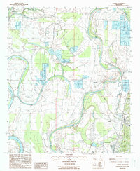
1988 Map of Carter
USGS Topo · Published 1988About this map
The Yazoo River defines this landscape on the edge of the Delta, winding through a complex network of levees and oxbow formations like Wolf Lake and Five Mile Lake. In the late 1980s, this area north of Yazoo City shows a transition toward modern land use, including several Fish Farm operations and the Muni Airport. The Illinois Central Gulf Railroad remains a central corridor, passing through settlements like Carter and Yazoo Junction.
Find a feature on this map
23 named features on this map. Tap any name to fly to it.
Don’t see what you’re looking for? This feature index may not catch every label — zoom into the map to look around manually.
Map Details
Editions of this 1988 Carter Map
This is the sole edition of this map. No revisions or reprints were ever made.
Other maps of this area

1940 · Auter
USGS Topo · 1:62,500

1940 · Mileston
USGS Topo · 1:62,500

1953 · Greenwood
USGS Topo · 1:250,000

1954 · Mileston
USGS Topo · 1:62,500

1955 · Jackson
USGS Topo · 1:250,000

1956 · Greenwood
USGS Topo · 1:250,000

1961 · Jackson
USGS Topo · 1:250,000

1961 · Bayland
USGS Topo · 1:62,500

1961 · Valley
USGS Topo · 1:62,500

1962 · Jackson
USGS Topo · 1:250,000