
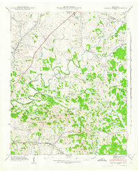
1941 Map of Carters Creek
USGS Topo · Published 1941About this map
The Andrew Jackson Highway and the Louisville and Nashville railroad cut a diagonal path through this 1941 landscape, marking the transition from the rolling terrain of southern Williamson Co into the heart of Maury Co. This era of Central Tennessee is defined by a dense network of rural infrastructure, where small settlements like Carters Creek and Neapolis serve as hubs for a agrarian society. A significant industrial landmark, the Phosphate Mine near Bear Creek, highlights the region's mineral wealth during the early 1940s.
Find a feature on this map
64 named features on this map. Tap any name to fly to it.
Don’t see what you’re looking for? This feature index may not catch every label — zoom into the map to look around manually.
Map Details
Editions of this 1941 Carters Creek Map
2 editions found
Other maps of this area

1901 · Colombia
USGS Topo · 1:125,000

1909 · Franklin
USGS Topo · 1:62,500

1936 · Godwin
USGS Topo · 1:24,000

1936 · Verona
USGS Topo · 1:24,000

1936 · Rally Hill
USGS Topo · 1:24,000

1936 · Spring Hill
USGS Topo · 1:24,000

1936 · Theta
USGS Topo · 1:24,000

1936 · Carters Creek
USGS Topo · 1:24,000

1936 · Glendale
USGS Topo · 1:24,000

1936 · Columbia
USGS Topo · 1:24,000