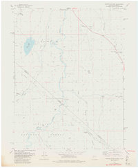
1979 Map of Carters Station
USGS Topo · Published 1980About this map
East Fork Carson River winds through this high-desert landscape on the border of Nevada and California, serving as the central artery for the surrounding valleys. Near the northern edge, the Washoe Indian Res (Dresslerville Colony) and the Washoe Cem provide significant genealogical touchpoints for the region's tribal history. The map details a network of canyons and flats, where small outposts like Carters Station and River Ranch are linked by trails and rugged crossings such as Youngs Crossing.
Find a feature on this map
35 named features on this map. Tap any name to fly to it.
Don’t see what you’re looking for? This feature index may not catch every label — zoom into the map to look around manually.
Map Details
Editions of this 1979 Carters Station Map
2 editions found
Other maps of this area

1889 · Markleeville
USGS Topo · 1:125,000

1891 · Markleeville
USGS Topo · 1:125,000

1893 · Markleeville
USGS Topo · 1:125,000

1948 · Walker Lake
USGS Topo · 1:250,000

1956 · Freel Peak
USGS Topo · 1:62,500

1956 · Topaz Lake
USGS Topo · 1:62,500

1956 · Markleeville
USGS Topo · 1:62,500

1957 · Walker Lake
USGS Topo · 1:250,000
1957 · Mt. Siegel
USGS Topo · 1:62,500

1962 · Walker Lake
USGS Topo · 1:250,000