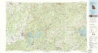
1981 Map of Cartersville
USGS Topo · Published 1982About this map
The Etowah River corridor anchors this regional study, flowing past the ancient Etowah Mounds and through the massive reservoir created by the Allatoona Dam. This landscape is defined by the transition from the rolling Piedmont to the southern foothills of the Blue Ridge, with Mount Oglethorpe and Pine Log Mountain serving as prominent northern landmarks. The era’s transportation network is well-defined, showing the intersection of the L & N RR and Sou RY rail lines with the growing Interstate and highway systems connecting Cartersville, Canton, and Alpharetta.
Find a feature on this map
253 named features on this map. Tap any name to fly to it.
Don’t see what you’re looking for? This feature index may not catch every label — zoom into the map to look around manually.
Map Details
Editions of this 1981 Cartersville Map
2 editions found
Other maps of this area

1886 · Dalton
USGS Topo · 1:125,000

1886 · Ringgold
USGS Topo · 1:125,000

1886 · Rome
USGS Topo · 1:125,000

1886 · Dahlonega
USGS Topo · 1:125,000

1888 · Ellijay
USGS Topo · 1:125,000

1888 · Atlanta
USGS Topo · 1:125,000

1889 · Tallapoosa
USGS Topo · 1:125,000

1890 · Suwanee
USGS Topo · 1:125,000

1890 · Cartersville
USGS Topo · 1:125,000

1890 · Atlanta
USGS Topo · 1:125,000