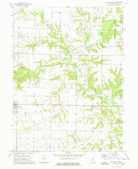
1974 Map of Carthage East
USGS Topo · Published 1978About this map
The eastern edges of Carthage and the surrounding prairie of Hancock County are defined by a complex drainage network where the La Moine River winds through wooded bottomlands. This mid-1970s survey captures the landscape during a period of academic and industrial presence, featuring the Robert Morris Jr College campus and various municipal infrastructure like a Sew Disp and Radio Tower. The agricultural character of the region is punctuated by family-named landmarks and several rural burial grounds, including McKay Cem and Woodring Cem, which offer significant value for genealogical research.
Find a feature on this map
30 named features on this map. Tap any name to fly to it.
Don’t see what you’re looking for? This feature index may not catch every label — zoom into the map to look around manually.
Map Details
Editions of this 1974 Carthage East Map
This is the sole edition of this map. No revisions or reprints were ever made.
Other maps of this area

1913 · Colchester
USGS Topo · 1:62,500

1918 · La Harpe
USGS Topo · 1:62,500

1932 · Lomax
USGS Topo · 1:62,500

1933 · Carthage
USGS Topo · 1:62,500

1937 · Carthage
USGS Topo · 1:62,500

1937 · Lomax
USGS Topo · 1:62,500

1958 · Burlington
USGS Topo · 1:250,000

1961 · Burlington
USGS Topo · 1:250,000

1963 · Burlington
USGS Topo · 1:250,000
1964 · Colusa
USGS Topo · 1:24,000