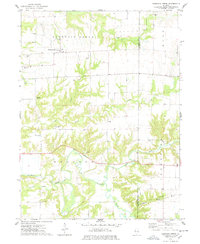
1974 Map of Fountain Green
USGS Topo · Published 1978About this map
Fountain Green and Webster anchor the northern landscape of this west-central Illinois survey, an area defined by agricultural plateaus dissected by winding creek valleys. The drainage system of the East Fork La Moine River creates a complex topography of ridges and hollows in the south, including the distinctively named Battlesnake Den Hollow. This 1970s record highlights a community deeply connected to its local heritage, evidenced by numerous family and community burial grounds such as McConnell Cem, Wright Cem, and Lincoln Cem. Small rural centers like Joetta and religious landmarks such as Majorville Ch and Oak Grove Ch illustrate the dispersed settlement pattern of the Hancock and Tennessee townships during this era. The map also identifies local activity at the Sandpit and the La Moine Camp, providing a detailed look at the land use and social geography of the county line.
Find a feature on this map
29 named features on this map. Tap any name to fly to it.
Don’t see what you’re looking for? This feature index may not catch every label — zoom into the map to look around manually.
Map Details
Editions of this 1974 Fountain Green Map
This is the sole edition of this map. No revisions or reprints were ever made.
Other maps of this area

1913 · Colchester
USGS Topo · 1:62,500

1918 · La Harpe
USGS Topo · 1:62,500

1932 · Lomax
USGS Topo · 1:62,500

1933 · Carthage
USGS Topo · 1:62,500

1937 · Carthage
USGS Topo · 1:62,500

1937 · Lomax
USGS Topo · 1:62,500

1958 · Burlington
USGS Topo · 1:250,000

1961 · Burlington
USGS Topo · 1:250,000

1963 · Burlington
USGS Topo · 1:250,000
1964 · Burnside
USGS Topo · 1:24,000