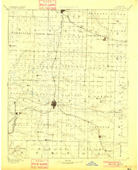
1894 Map of Carthage
USGS Topo · Published 1901About this map
Carthage serves as the central hub for Southwest Missouri in this late nineteenth-century reconnaissance, situated at the junction of the Missouri Pacific Railroad and branches of the St. Louis and San Francisco Railroad. The landscape is defined by the winding course of the Spring River and its numerous tributaries like Center Creek and Shoal Creek, which provided power and water for early industry. Small agricultural and mining outposts such as Oronogo, Carterville, and Webb City appear as burgeoning centers, while the northern reaches include the planned grids of Lamar and Golden City. This era shows the region in a state of rapid development, with the rail lines of the Kansas City Fort Scott and Memphis R.R. connecting disparate rural townships like Nashville and Sarcoxie to broader markets, just as traditional milling sites like Bowers Mill continued to serve local farmers.
Find a feature on this map
71 named features on this map. Tap any name to fly to it.
Don’t see what you’re looking for? This feature index may not catch every label — zoom into the map to look around manually.
Map Details
Editions of this 1894 Carthage Map
5 editions found

Other maps of this area

1884 · Fort Scott
USGS Topo · 1:125,000

1886 · Nevada
USGS Topo · 1:125,000

1886 · Joplin
USGS Topo · 1:125,000

1886 · Stockton
USGS Topo · 1:125,000

1886 · Greenfield
USGS Topo · 1:125,000

1886 · Fort Scott
USGS Topo · 1:125,000

1886 · Carthage
USGS Topo · 1:125,000

1888 · Greenfield
USGS Topo · 1:125,000

1893 · Fort Scott
USGS Topo · 1:125,000

1894 · Nevada
USGS Topo · 1:125,000