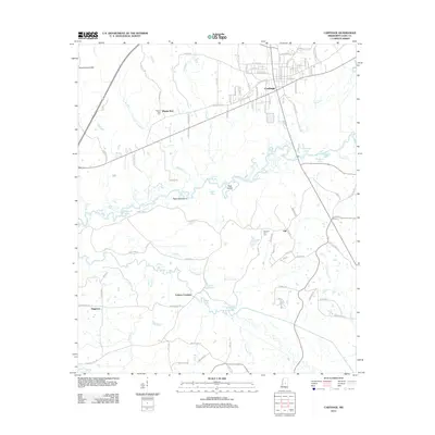
2012 Map of Carthage
USGS Topo · Published 2012About this map
Carthage serves as the focal point of this Leake County survey, situated above the winding course of the Pearl River. The landscape is defined by an intricate network of waterways, including Pellahalla Cr, Town Cr, and Yellow Cr, which feed into numerous oxbow lakes such as Coles Ford Lake and Adair Lake. Notable landmarks like Government Hills and Peach Tree Island provide topographic variation in a region otherwise dominated by creek bottoms and wetlands like Duck Pond Slough. Small settlements and rural junctions like Piggtown and Gill are connected by a web of local roads, including Old Canton Rd. For those researching local history or genealogy, the map identifies significant sites such as Pilgrim Rest Cem and Pleasant Hill Cem, which offer physical connections to the families who established these central Mississippi communities.
Find a feature on this map
103 named features on this map. Tap any name to fly to it.
Don’t see what you’re looking for? This feature index may not catch every label — zoom into the map to look around manually.
Map Details
Editions of this 2012 Carthage Map
This is the sole edition of this map. No revisions or reprints were ever made.
Other maps of this area

1953 · Meridian
USGS Topo · 1:250,000

1957 · Meridian
USGS Topo · 1:250,000

1961 · Carthage
USGS Topo · 1:62,500

1962 · Edinburg
USGS Topo · 1:62,500

1962 · Thomastown
USGS Topo · 1:62,500

1965 · Meridian
USGS Topo · 1:250,000

1972 · McAfee
USGS Topo · 1:24,000
1972 · Walnut Grove
USGS Topo · 1:24,000

1984 · Carthage
USGS Topo · 1:100,000
1988 · Thomastown
USGS Topo · 1:24,000