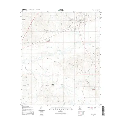
2015 Map of Carthage
USGS Topo · Published 2015About this map
Carthage sits at the northern edge of this Central Mississippi landscape, where the street grid of the county seat transitions into a complex network of river bottoms and wooded hills. The Pearl River dominates the central geography, carving a wide floodplain that includes Peach Tree Island and Deal Island. This 2015 survey reveals how the local economy and settlement patterns are tethered to these waterways and the surrounding high ground of the Government Hills.
Find a feature on this map
91 named features on this map. Tap any name to fly to it.
Don’t see what you’re looking for? This feature index may not catch every label — zoom into the map to look around manually.
Map Details
Editions of this 2015 Carthage Map
This is the sole edition of this map. No revisions or reprints were ever made.
Other maps of this area

1953 · Meridian
USGS Topo · 1:250,000

1957 · Meridian
USGS Topo · 1:250,000

1961 · Carthage
USGS Topo · 1:62,500

1962 · Edinburg
USGS Topo · 1:62,500

1962 · Thomastown
USGS Topo · 1:62,500

1965 · Meridian
USGS Topo · 1:250,000

1972 · McAfee
USGS Topo · 1:24,000
1972 · Walnut Grove
USGS Topo · 1:24,000

1984 · Carthage
USGS Topo · 1:100,000
1988 · Thomastown
USGS Topo · 1:24,000