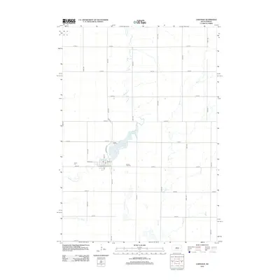
2012 Map of Carthage
USGS Topo · Published 2012About this map
Carthage serves as the primary hub in this portion of Miner County, situated near the headwaters of Redstone Cr. The community layout is centered around Main St W and Main St E, with a local Po marking the center of town. The landscape is defined by the prairie water system, featuring the prominent Lake Carthage just north of the residential blocks. This artificial reservoir and the surrounding drainage of Rock Cr and Jim Cr illustrate the managed hydrology typical of South Dakota's agricultural heartland. Several burial grounds, including Pleasant View Cem, Sacred Heart Cem, and Trinity Cem, are distributed around the town perimeter, providing valuable points of reference for local family history and genealogical research in the township.
Find a feature on this map
35 named features on this map. Tap any name to fly to it.
Don’t see what you’re looking for? This feature index may not catch every label — zoom into the map to look around manually.
Map Details
Editions of this 2012 Carthage Map
This is the sole edition of this map. No revisions or reprints were ever made.
Other maps of this area

1899 · De Smet
USGS Topo · 1:125,000

1953 · Watertown
USGS Topo · 1:250,000

1958 · Watertown
USGS Topo · 1:250,000

1971 · Iroquois
USGS Topo · 1:24,000

1971 · Howard NE
USGS Topo · 1:24,000

1971 · Fedora
USGS Topo · 1:24,000

1971 · De Smet SE
USGS Topo · 1:24,000

1971 · Artesian NE
USGS Topo · 1:24,000

1971 · Howard
USGS Topo · 1:24,000
1971 · Carthage
USGS Topo · 1:24,000