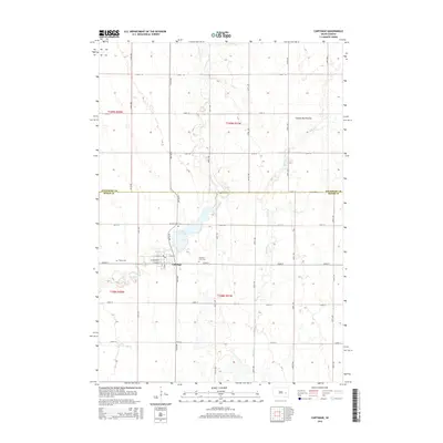
2015 Map of Carthage
USGS Topo · Published 2015About this map
Carthage sits at the heart of this agricultural landscape in Miner County, positioned just south of the Kingsbury County line. The town's grid is anchored by West Main Street and East Main Street, serving as a central hub for the surrounding township. To the north, Lake Carthage provides a prominent water feature in a region defined by the subtle elevations of the Coteau des Prairies. The local genealogy and history of the community are preserved at several sites, including Sacred Heart Cem and Pleasant View Cem near the town center, and Trinity Cem to the west. A network of section-line roads like 217th Street and 425th Avenue divide the prairie, while natural drainages such as Redstone Creek, Rock Creek, and Jim Creek meander through the farmland, illustrating the persistent drainage patterns of the eastern South Dakota plains.
Find a feature on this map
33 named features on this map. Tap any name to fly to it.
Don’t see what you’re looking for? This feature index may not catch every label — zoom into the map to look around manually.
Map Details
Editions of this 2015 Carthage Map
This is the sole edition of this map. No revisions or reprints were ever made.
Other maps of this area

1899 · De Smet
USGS Topo · 1:125,000

1953 · Watertown
USGS Topo · 1:250,000

1958 · Watertown
USGS Topo · 1:250,000

1971 · Iroquois
USGS Topo · 1:24,000

1971 · Howard NE
USGS Topo · 1:24,000

1971 · Fedora
USGS Topo · 1:24,000

1971 · De Smet SE
USGS Topo · 1:24,000

1971 · Artesian NE
USGS Topo · 1:24,000

1971 · Howard
USGS Topo · 1:24,000
1971 · Carthage
USGS Topo · 1:24,000