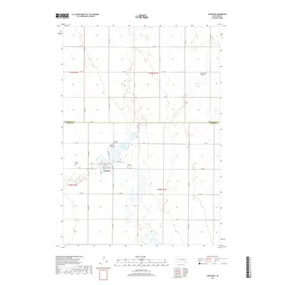
2017 Map of Carthage
USGS Topo · Published 2017About this map
Carthage serves as the central hub of this agricultural landscape in the north-central United States, situated where Kingsbury Co and Miner Co meet. The settlement is defined by its organized grid, including streets like Main St and Omaha St, and its proximity to the waters of Lake Carthage. This region sits upon the Coteau des Prairies, a high plateau reflected here by the winding paths of Redstone Cr and Rock Cr. The map is particularly useful for genealogical research, documenting several local burial sites such as Sacred Heart Cem and Pleasant View Cem, alongside the Trinity Lutheran Cem. The surrounding township is marked by a precise network of section lines and rural roads, illustrating the enduring homestead pattern of the Great Plains.
Find a feature on this map
40 named features on this map. Tap any name to fly to it.
Don’t see what you’re looking for? This feature index may not catch every label — zoom into the map to look around manually.
Map Details
Editions of this 2017 Carthage Map
This is the sole edition of this map. No revisions or reprints were ever made.
Other maps of this area

1899 · De Smet
USGS Topo · 1:125,000

1953 · Watertown
USGS Topo · 1:250,000

1958 · Watertown
USGS Topo · 1:250,000

1971 · Iroquois
USGS Topo · 1:24,000

1971 · Howard NE
USGS Topo · 1:24,000

1971 · Fedora
USGS Topo · 1:24,000

1971 · De Smet SE
USGS Topo · 1:24,000

1971 · Artesian NE
USGS Topo · 1:24,000

1971 · Howard
USGS Topo · 1:24,000
1971 · Carthage
USGS Topo · 1:24,000