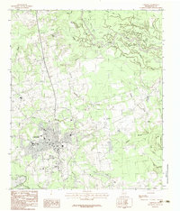
1983 Map of Carthage
USGS Topo · Published 1983About this map
Carthage serves as the focal point of this 1983 Panola County survey, showcasing the town's expansion and infrastructure during the early 1980s. The presence of Panola Jr College and the Panola County Airport highlights the area's development as a regional hub. North of the town center, the small settlement of Walnut Grove is situated near the winding course of Irons Bayou, while the northeast corner is dominated by the complex hydrology of the Sabine River and its numerous backwaters, including The Basin and Horseshoe Lake.
Find a feature on this map
38 named features on this map. Tap any name to fly to it.
Don’t see what you’re looking for? This feature index may not catch every label — zoom into the map to look around manually.
Map Details
Editions of this 1983 Carthage Map
This is the sole edition of this map. No revisions or reprints were ever made.
Other maps of this area

1943 · Waskom
USGS Topo · 1:62,500

1945 · Waskom
USGS Topo · 1:62,500

1945 · Socagee Bayou
USGS Topo · 1:62,500

1956 · Tyler
USGS Topo · 1:250,000

1956 · Deadwood
USGS Topo · 1:62,500

1958 · Darco
USGS Topo · 1:62,500

1958 · Carthage
USGS Topo · 1:62,500

1962 · De Berry
USGS Topo · 1:24,000

1983 · Grand Bluff
USGS Topo · 1:24,000

1983 · Harris Chapel
USGS Topo · 1:24,000