
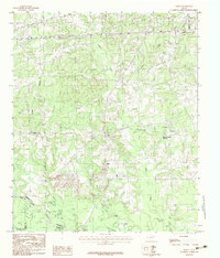
1983 Map of Harris Chapel
USGS Topo · Published 1983About this map
Harris Chapel and Center Point anchor this East Texas landscape where the Sabine River winds through a complex network of wetlands and oxbow formations. The river corridor is defined by numerous water features including Old River Lakes, Alligator Hole, and Trout Lake, alongside sprawling drainage systems like Black Slough and Cypress Slough. To the south, the terrain transitions from the river bottomlands toward The Sandy Hills and the settlement of Beckville. The map illustrates the 1983 boundaries between Panola, Harrison, and Rusk counties, capturing a moment when local creek systems like Martin Creek and Johnson Creek dictated the placement of small communities and rural roads across these undulating woodlands and low-lying marshes.
Find a feature on this map
31 named features on this map. Tap any name to fly to it.
Don’t see what you’re looking for? This feature index may not catch every label — zoom into the map to look around manually.
Map Details
Editions of this 1983 Harris Chapel Map
This is the sole edition of this map. No revisions or reprints were ever made.
Other maps of this area

1956 · Tyler
USGS Topo · 1:250,000

1958 · Darco
USGS Topo · 1:62,500

1958 · Carthage
USGS Topo · 1:62,500

1958 · Tatum
USGS Topo · 1:62,500

1960 · Minden
USGS Topo · 1:62,500

1983 · Grand Bluff
USGS Topo · 1:24,000

1983 · Tatum
USGS Topo · 1:24,000

1983 · Easton
USGS Topo · 1:24,000

1983 · Fair Play
USGS Topo · 1:24,000
1983 · Darco
USGS Topo · 1:24,000