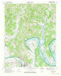
1968 Map of Carthage
USGS Topo · Published 1970About this map
Carthage and South Carthage sit at a critical bend where the Cumberland River meets the northern reaches of the Old Hickory Lake impoundment. This 1968 field-checked survey captures the landscape just as the Cordell Hull Reservoir was being established, centered on the Cordell Hull Lock and Dam. The terrain is defined by dramatic river loops like Horse Shoe Bend and Sullivan Bend, where the rising waters began to reshape the valley floor. Away from the river, the map documents a network of rural communities and hollows, including Monoville, Difficult, and Tony. Genealogists will find a wealth of specific data points, from small family-named landmarks like Saltpeter Hill and Tater Knob to numerous country churches such as Cornwell Chapel and Peyton Creek Ch. The presence of the County High Sch and Fairgrounds in the county seat highlights the area's role as a regional hub.
Find a feature on this map
71 named features on this map. Tap any name to fly to it.
Don’t see what you’re looking for? This feature index may not catch every label — zoom into the map to look around manually.
Map Details
Editions of this 1968 Carthage Map
2 editions found
Other maps of this area

1928 · Gordonsville
USGS Topo · 1:62,500

1932 · Carthage
USGS Topo · 1:62,500

1942 · Statesville
USGS Topo · 1:100,000

1956 · Corbin
USGS Topo · 1:250,000

1956 · Nashville
USGS Topo · 1:250,000

1958 · New Middleton
USGS Topo · 1:24,000

1958 · Corbin
USGS Topo · 1:250,000

1958 · Dixon Springs
USGS Topo · 1:24,000

1959 · Nashville
USGS Topo · 1:250,000
1959 · Hillsdale
USGS Topo · 1:24,000