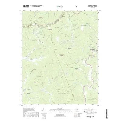
2019 Map of Carvers Gap
USGS Topo · Published 2019About this map
The high ridgelines of the Blue Ridge Mountains dominate this 2019 survey, defined by the towering Roan Mtn and Roan High Knob. The state line between Tennessee and North Carolina cuts across the northern peaks, where the Appalachian National Scenic Trail traverses legendary high-altitude features like Grassy Ridge Bald and Jane Bald. Below the peaks, the landscape is deeply etched by the North Toe River valley and its many tributaries, including Roaring Cr and Plumtree Cr. This map captures a mosaic of protected lands, including the Cherokee National Forest and Pisgah National Forest. Small mountain communities and family landmarks are preserved in detail, from the Greene Cove Ch to numerous high-elevation burial sites such as Pittman Cem and Ollis Cem, reflecting the deep-rooted settlement patterns of the Avery and Mitchell county lines.
Find a feature on this map
171 named features on this map. Tap any name to fly to it.
Don’t see what you’re looking for? This feature index may not catch every label — zoom into the map to look around manually.
Map Details
Editions of this 2019 Carvers Gap Map
This is the sole edition of this map. No revisions or reprints were ever made.
Other maps of this area

1891 · Roan Mountain
USGS Topo · 1:125,000

1893 · Cranberry
USGS Topo · 1:125,000

1894 · Roan Mountain
USGS Topo · 1:125,000

1895 · Cranberry
USGS Topo · 1:125,000

1899 · Cranberry
USGS Topo · 1:125,000

1900 · Mount Mitchell
USGS Topo · 1:125,000

1902 · Cranberry
USGS Topo · 1:125,000

1902 · Mount Mitchell
USGS Topo · 1:125,000

1904 · Roan Mountain
USGS Topo · 1:125,000

1905 · Morganton
USGS Topo · 1:125,000