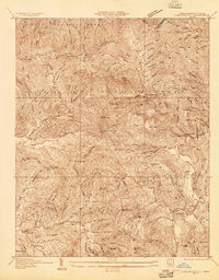
1934 Map of Carvers Gap
USGS Topo · Published 1934About this map
Roan Mountain dominates the northwestern skyline of this 1934 survey, where the high ridges of the Pisgah National Forest meet the state line. The landscape is defined by the sharp verticality of the Blue Ridge, punctuated by high-altitude gaps such as Carvers Gap and Engine Gap. Below these peaks, the terrain is carved by the North Toe River and its numerous tributaries, including Roaring Creek and Cane Creek.
Find a feature on this map
107 named features on this map. Tap any name to fly to it.
Don’t see what you’re looking for? This feature index may not catch every label — zoom into the map to look around manually.
Map Details
Editions of this 1934 Carvers Gap Map
This is the sole edition of this map. No revisions or reprints were ever made.
Other maps of this area

1891 · Roan Mountain
USGS Topo · 1:125,000

1893 · Cranberry
USGS Topo · 1:125,000

1894 · Roan Mountain
USGS Topo · 1:125,000

1895 · Cranberry
USGS Topo · 1:125,000

1899 · Cranberry
USGS Topo · 1:125,000

1900 · Mount Mitchell
USGS Topo · 1:125,000

1902 · Cranberry
USGS Topo · 1:125,000

1902 · Mount Mitchell
USGS Topo · 1:125,000

1904 · Roan Mountain
USGS Topo · 1:125,000
1905 · Morganton
USGS Topo · 1:125,000