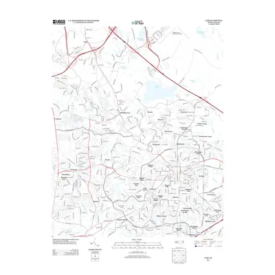
2013 Map of Cary
USGS Topo · Published 2013About this map
Morrisville sits at the heart of this suburban transition during the early 21st century, where the dense road networks of the Research Triangle Park area converge. The landscape is defined by a intricate mosaic of planned residential developments, ranging from established neighborhoods like Kildaire Farms and Greenwood Acres to newer enclaves such as Dublin Woods and Hearthstone Farms. This era of growth is marked by the presence of large corporate and industrial corridors along I-40 and I-540, which snake through former woodland and farmland near Clegg.
Find a feature on this map
73 named features on this map. Tap any name to fly to it.
Don’t see what you’re looking for? This feature index may not catch every label — zoom into the map to look around manually.
Map Details
Editions of this 2013 Cary Map
This is the sole edition of this map. No revisions or reprints were ever made.
Other maps of this area

1943 · Durham South
USGS Topo · 1:62,500

1943 · Raleigh
USGS Topo · 1:62,500

1951 · Raleigh
USGS Topo · 1:62,500

1951 · Durham South
USGS Topo · 1:62,500

1953 · Raleigh
USGS Topo · 1:250,000

1954 · Raleigh
USGS Topo · 1:250,000

1964 · Lake Wheeler
USGS Topo · 1:24,000

1964 · Garner
USGS Topo · 1:62,500
1967 · Bayleaf
USGS Topo · 1:24,000

1968 · Raleigh West
USGS Topo · 1:24,000