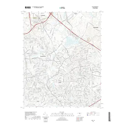
2019 Map of Cary
USGS Topo · Published 2019About this map
Cary and Morrisville anchor this 2019 survey, illustrating the modern expansion of the Research Triangle. The landscape is defined by the extensive footprint of the Raleigh-Durham International Airport and the complex web of transport links such as Aviation Pkwy and Weston Pkwy. Despite the rapid suburbanization and commercial growth, older community landmarks like Good Hope Church, Hill Crest Cem, and the small settlement of Carpenter remain part of the map's fabric. Significant water features, including Lake Crabtree and Beaverdam Lake, offer a look at the region's managed watersheds and recreational greenways. This record captures a moment where legacy rural hubs like Clegg and Upchurch are increasingly integrated into the larger metropolitan reach of Raleigh and Durham.
Find a feature on this map
72 named features on this map. Tap any name to fly to it.
Don’t see what you’re looking for? This feature index may not catch every label — zoom into the map to look around manually.
Map Details
Editions of this 2019 Cary Map
This is the sole edition of this map. No revisions or reprints were ever made.
Other maps of this area

1943 · Durham South
USGS Topo · 1:62,500

1943 · Raleigh
USGS Topo · 1:62,500

1951 · Raleigh
USGS Topo · 1:62,500

1951 · Durham South
USGS Topo · 1:62,500

1953 · Raleigh
USGS Topo · 1:250,000

1954 · Raleigh
USGS Topo · 1:250,000

1964 · Lake Wheeler
USGS Topo · 1:24,000

1964 · Garner
USGS Topo · 1:62,500
1967 · Bayleaf
USGS Topo · 1:24,000

1968 · Raleigh West
USGS Topo · 1:24,000