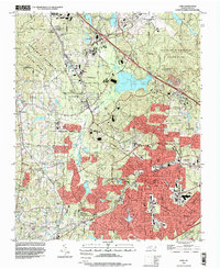
1993 Map of Cary
USGS Topo · Published 1999About this map
Morrisville and Cary anchor this 1993 study of the growing North Carolina Research Triangle, a landscape defined by rapid suburban expansion and significant institutional footprints. The map details the transition from rural crossroads like Clegg, Carpenter, and Upchurch to a regional hub, with the expansive Raleigh-Durham Airport and Research Triangle State Park occupying the northern quadrants. Local community life is evidenced by numerous country congregations such as Shiloh Ch, Sorrels Grove Ch, and Reedy Creek Com Ch. The drainage network, including Crabtree Creek and Brier Creek, provides the topography for large protected areas like William B Umstead State Park. Transportation corridors are well-developed, featuring the Durham and Southern railroad and several major highway interchanges that were instrumental in the area's late 20th-century development.
Find a feature on this map
55 named features on this map. Tap any name to fly to it.
Don’t see what you’re looking for? This feature index may not catch every label — zoom into the map to look around manually.
Map Details
Editions of this 1993 Cary Map
This is the sole edition of this map. No revisions or reprints were ever made.
Other maps of this area

1943 · Durham South
USGS Topo · 1:62,500

1943 · Raleigh
USGS Topo · 1:62,500

1951 · Raleigh
USGS Topo · 1:62,500

1951 · Durham South
USGS Topo · 1:62,500

1953 · Raleigh
USGS Topo · 1:250,000

1954 · Raleigh
USGS Topo · 1:250,000

1964 · Lake Wheeler
USGS Topo · 1:24,000

1964 · Garner
USGS Topo · 1:62,500
1967 · Bayleaf
USGS Topo · 1:24,000

1968 · Raleigh West
USGS Topo · 1:24,000