
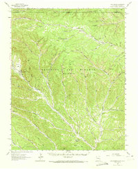
1962 Map of Casa Grande
USGS Topo · Published 1965About this map
The Beaubien and Miranda (Maxwell) land grant dominates this 1960s landscape, illustrating a complex network of canyons and high-elevation ranching camps. The map traces the Old Railroad Grade as it winds through the northern reaches near Lorencito and the Catskill (Site), marking the remnants of earlier industrial activity. Settlement patterns are defined by isolated outposts such as Armstrong Camp, W S Ranch Camp, and Horse Ranch Camp, which served the vast cattle operations of the era. To the west, Vermejo Park and the Vermejo River provide a geographical anchor, while unique historical markers like the Charcoal Kilns and a lone Cemetery near Cemetery Canyon offer specific points of interest for local historians. The terrain is deeply incised by countless drainages, including Caliente Canyon and Salyers Canyon, which dictated the placement of early jeep trails and ranch boundaries.
Find a feature on this map
66 named features on this map. Tap any name to fly to it.
Don’t see what you’re looking for? This feature index may not catch every label — zoom into the map to look around manually.
Map Details
Editions of this 1962 Casa Grande Map
2 editions found
Other maps of this area

1891 · Spanish Peaks
USGS Topo · 1:125,000

1893 · Spanish Peaks
USGS Topo · 1:125,000

1895 · Spanish Peaks
USGS Topo · 1:125,000

1897 · Spanish Peaks
USGS Topo · 1:125,000

1900 · Spanish Peaks
USGS Topo · 1:125,000

1915 · Brilliant
USGS Topo · 1:62,500

1915 · Koehler
USGS Topo · 1:62,500

1917 · Koehler
USGS Topo · 1:62,500

1951 · Valdez
USGS Topo · 1:24,000

1954 · Raton
USGS Topo · 1:250,000