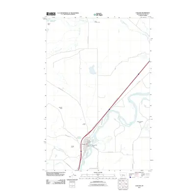
2011 Map of Cascade
USGS Topo · Published 2011About this map
The Missouri River winds through this landscape, serving as a vital corridor for transportation and water management in the early 21st century. The town of Cascade sits along its banks, anchored by essential infrastructure like the Missouri River Bridge, the Cascade Post Office, and local emergency services including the Cascade Vol Fire Dept. This area represents a blend of agricultural utility and aviation history, evidenced by the Cascade Airport and the complex irrigation network suggested by the Webb Number 1 Dam and Rocky Reef Reservoir.
Find a feature on this map
34 named features on this map. Tap any name to fly to it.
Don’t see what you’re looking for? This feature index may not catch every label — zoom into the map to look around manually.
Map Details
Editions of this 2011 Cascade Map
This is the sole edition of this map. No revisions or reprints were ever made.
Other maps of this area

1886 · Great Falls
USGS Topo · 1:250,000

1949 · Cascade
USGS Topo · 1:62,500

1951 · Cascade
USGS Topo · 1:62,500

1954 · Great Falls
USGS Topo · 1:250,000

1957 · Great Falls
USGS Topo · 1:250,000

1960 · Simms
USGS Topo · 1:62,500

1961 · Hardy
USGS Topo · 1:24,000

1961 · Rocky Reef
USGS Topo · 1:24,000

1961 · Schrammeck Lake
USGS Topo · 1:24,000
1976 · Great Falls South
USGS Topo · 1:100,000