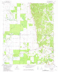
1981 Map of Cascilla
USGS Topo · Published 1982About this map
Cascilla and Oxberry anchor the eastern hills of this 1980s landscape, where the flat alluvial plains of the Delta meet the rising uplands. The drainage pattern is complex, defined by the winding Yalobusha River and numerous waterways like Rattlesnake Creek and Oxberry Bayou. A notable concentration of community landmarks exists near the county line, including Turkey Foot Rock Ch, Oxberry Cem, and St Peter Ch. The western portion of the map is dominated by the seasonal wetlands and agricultural fields of the bottomlands, marked by Flat Lake and Elliott Lake. This area also includes the northern reach of the Malmaison State Wildlife Management Area and the La Belle Landing Field, reflecting the region's mix of conservation land and rural infrastructure during this era.
Find a feature on this map
40 named features on this map. Tap any name to fly to it.
Don’t see what you’re looking for? This feature index may not catch every label — zoom into the map to look around manually.
Map Details
Editions of this 1981 Cascilla Map
This is the sole edition of this map. No revisions or reprints were ever made.
Other maps of this area

1932 · Philipp
USGS Topo · 1:48,000

1935 · Philipp
USGS Topo · 1:62,500

1936 · Greenwood
USGS Topo · 1:62,500

1939 · Philipp
USGS Topo · 1:62,500

1940 · Greenwood
USGS Topo · 1:62,500

1953 · Greenwood
USGS Topo · 1:250,000

1953 · West Point
USGS Topo · 1:250,000

1954 · Grenada
USGS Topo · 1:62,500

1954 · McCarley
USGS Topo · 1:62,500

1956 · Greenwood
USGS Topo · 1:250,000