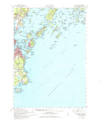
1957 Map of Casco Bay
USGS Topo · Published 1966About this map
Portland and the jagged islands of the Maine coastline emerge in detail during the late 1950s, a period when the region's deep military and maritime roots remained highly visible. The landscape is defined by its defensive history, featuring the Fort Mc Kinley Naval Res on Great Diamond Island and the Fort Williams Military Res standing guard over the harbor entrance. These fortifications, along with Fort Gorges and Fort Scammel, illustrate the strategic importance of this harbor through the mid-20th century.
Find a feature on this map
77 named features on this map. Tap any name to fly to it.
Don’t see what you’re looking for? This feature index may not catch every label — zoom into the map to look around manually.
Map Details
Editions of this 1957 Casco Bay Map
3 editions found
Other maps of this area

1891 · Portland
USGS Topo · 1:62,500

1891 · Biddeford
USGS Topo · 1:62,500

1892 · Freeport
USGS Topo · 1:62,500

1893 · Biddeford
USGS Topo · 1:62,500

1893 · Small Point
USGS Topo · 1:62,500

1893 · Portland
USGS Topo · 1:62,500

1893 · Casco Bay
USGS Topo · 1:62,500

1894 · Gray
USGS Topo · 1:62,500

1894 · Bath
USGS Topo · 1:62,500

1898 · Gray
USGS Topo · 1:62,500