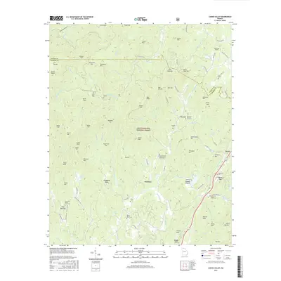
2017 Map of Cashes Valley
USGS Topo · Published 2017About this map
Chattahoochee National Forest lands dominate this northern Georgia landscape, where the border of Fannin and Gilmer counties winds through high ridges like Horse Ridge and Blue Ridge. The terrain is characterized by numerous gaps and knobs, including Bushy Head Gap and Frozen Knob, which hem in narrow valleys where small settlements like Ai and Santaluca are found. The map reveals a dense network of mountain cemeteries and rural houses of worship, such as the Mount Pleasant Baptist Church Cem Number 1 and the Boardtown Church of Christ Cem, serving the scattered communities along Cashes Valley Rd and Boardtown Cr. In the eastern corridor, the Ellijay River flows south toward White Path, paralleling the highway that connects Cherry Log and Lucius. This survey also documents the Blue Ridge Skyport tucked into the hills near Young Lake, illustrating the intersection of traditional Appalachian settlement patterns with modern infrastructure.
Find a feature on this map
127 named features on this map. Tap any name to fly to it.
Don’t see what you’re looking for? This feature index may not catch every label — zoom into the map to look around manually.
Map Details
Editions of this 2017 Cashes Valley Map
This is the sole edition of this map. No revisions or reprints were ever made.
Other maps of this area

1886 · Dalton
USGS Topo · 1:125,000

1888 · Ellijay
USGS Topo · 1:125,000

1892 · Ellijay
USGS Topo · 1:125,000

1892 · Dalton
USGS Topo · 1:125,000

1897 · Dalton
USGS Topo · 1:125,000

1898 · Ellijay
USGS Topo · 1:125,000

1911 · Ellijay
USGS Topo · 1:125,000

1911 · Cohutta Mtn
USGS Topo · 1:62,500

1913 · Cohutta Mtn.
USGS Topo · 1:62,500

1914 · Talking Rock
USGS Topo · 1:62,500