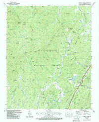
1988 Map of Cashes Valley
USGS Topo · Published 1988About this map
Fightingtown Creek flows through this corner of the North Georgia mountains, anchoring a landscape of family-named gaps and ridges within the Chattahoochee National Forest. This late-1980s data illustrates a transition from remote mountain homesteads toward localized development, with the Gilmer Co Golf Course appearing near White Path along the Ellijay River. Genealogists will find a detailed distribution of rural faith and burial sites, including the Cashes Valley Church of Christ and the Johnson Cem tucked behind Horse Ridge. Small settlements like Cherry Log and Santaluca sit along established valley routes, while 4-wheel drive tracks reach into the high country toward Hudson Gap and Frozen Knob. The map clearly delineates the Fannin and Gilmer County line as it cuts across the ridgelines of the Blue Ridge.
Find a feature on this map
94 named features on this map. Tap any name to fly to it.
Don’t see what you’re looking for? This feature index may not catch every label — zoom into the map to look around manually.
Map Details
Editions of this 1988 Cashes Valley Map
2 editions found
Other maps of this area

1886 · Dalton
USGS Topo · 1:125,000

1888 · Ellijay
USGS Topo · 1:125,000

1892 · Ellijay
USGS Topo · 1:125,000

1892 · Dalton
USGS Topo · 1:125,000

1897 · Dalton
USGS Topo · 1:125,000

1898 · Ellijay
USGS Topo · 1:125,000

1911 · Ellijay
USGS Topo · 1:125,000

1911 · Cohutta Mtn
USGS Topo · 1:62,500

1913 · Cohutta Mtn.
USGS Topo · 1:62,500

1914 · Talking Rock
USGS Topo · 1:62,500