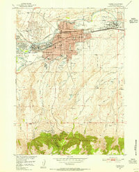
1951 Map of Casper
USGS Topo · Published 1953About this map
The North Platte River defines the industrial and urban core of the Casper vicinity in the early 1950s. The city's northern edge is heavily shaped by energy and transport, featuring an extensive Oil Tank Farm and the intersection of the Chicago and Northwestern and Chicago and Burlington railroads. Residential pockets like Midwest Heights, Thorndale Acres, and Allendale expand the footprint of the community, while the State Childrens Home and Natrona Co High School mark the social infrastructure of the era.
Find a feature on this map
59 named features on this map. Tap any name to fly to it.
Don’t see what you’re looking for? This feature index may not catch every label — zoom into the map to look around manually.
Map Details
Editions of this 1951 Casper Map
2 editions found
Other maps of this area

1949 · Brookhurst
USGS Topo · 1:24,000

1949 · Pratts Soda Lakes
USGS Topo · 1:24,000

1950 · Brookhurst
USGS Topo · 1:24,000

1950 · Pratts Soda Lakes
USGS Topo · 1:24,000

1950 · Goose Egg
USGS Topo · 1:24,000

1951 · The Reefs
USGS Topo · 1:24,000

1951 · Casper
USGS Topo · 1:24,000

1952 · Bishop
USGS Topo · 1:24,000

1955 · Casper
USGS Topo · 1:250,000

1958 · Casper
USGS Topo · 1:250,000