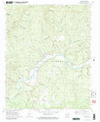
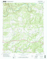
1973 Map of Cass
USGS Topo · Published 1988About this map
The Mulberry River winds through the heart of the Ozark National Forest, shaping a landscape of deep hollows and high ridges in northern Franklin County. This mid-1970s survey highlights a network of small, isolated settlements and family landmarks such as Cass, Turners Bend, and Paradise. The area’s genealogical record is well-preserved through numerous small burial sites, including the McIroy Cem, Turner Cem, and Plymale Cem, which are tucked away near creek branches and forest roads. Public lands are prominent, with the Redding Recreation Area and Cherry Bend Recreation Area providing access to the river's valley. High points like Fly Gap Mtn and Hare Mtn tower over the drainage basins of Fane Creek and Cripple Creek, illustrating the remote character of this Ozark highland before more modern development reached the interior forest corridors.
Find a feature on this map
57 named features on this map. Tap any name to fly to it.
Don’t see what you’re looking for? This feature index may not catch every label — zoom into the map to look around manually.
Map Details
Editions of this 1973 Cass Map
3 editions found
Other maps of this area

1879 · Cravens
USGS Topo · 1:62,500

1887 · Watalula
USGS Topo · 1:62,500

1906 · Batson
USGS Topo · 1:62,500

1939 · Watalula
USGS Topo · 1:62,500

1943 · St. Paul
USGS Topo · 1:62,500

1946 · St. Paul
USGS Topo · 1:62,500

1956 · Russellville
USGS Topo · 1:250,000
1963 · Hunt
USGS Topo · 1:24,000

1964 · Russellville
USGS Topo · 1:250,000
1973 · Cravens
USGS Topo · 1:24,000