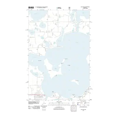
2011 Map of Cass Lake
USGS Topo · Published 2011About this map
The northern reaches of Cass Lake dominate this landscape, defined by a complex geography of peninsulas and interior islands. The unique geography of Star Island stands out, containing its own body of water, Lake Windigo, and the historical Lake Windigo Portage and Yellow Head Canoe Stop. This area is a significant hub for recreation and regional travel, evidenced by the cluster of sites like Star Island Campground and Stony Point Campgrounds along the shoreline. In the southwestern corner, the settlement of Cass Lake serves as a local anchor, featuring the Cass Lake Post Office and Cass Lake Rest Area along the main transit corridor. The map reveals a transition from the developed townsite and the Sandtrap Golf Course to the primitive forest and water-accessible sites of the northern lakes, including Big Lake, Kitchi Lake, and Pug Hole Lake.
Find a feature on this map
46 named features on this map. Tap any name to fly to it.
Don’t see what you’re looking for? This feature index may not catch every label — zoom into the map to look around manually.
Map Details
Editions of this 2011 Cass Lake Map
This is the sole edition of this map. No revisions or reprints were ever made.
Other maps of this area

1919 · Rosy
USGS Topo · 1:62,500

1954 · Bemidji
USGS Topo · 1:250,000

1957 · Bemidji
USGS Topo · 1:250,000

1958 · Bemidji
USGS Topo · 1:250,000

1971 · Gimmer Lake
USGS Topo · 1:24,000

1971 · Sucker Lakes
USGS Topo · 1:24,000

1971 · Pennington
USGS Topo · 1:24,000

1972 · Turtle River Lake
USGS Topo · 1:24,000
1972 · Pimushe Lake
USGS Topo · 1:24,000

1972 · Pike Bay
USGS Topo · 1:24,000