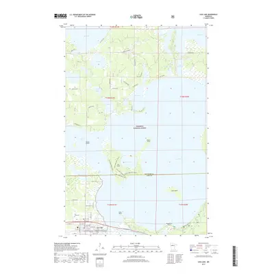
2019 Map of Cass Lake
USGS Topo · Published 2019About this map
Chippewa National Forest dominates this northern Minnesota landscape, where the waters of Cass Lake and Big Lake define the terrain. At the southern edge of the sheet, the town of Cass Lake serves as a hub, containing the Leech Lake Tribal College and the Pine Grove Cem. A distinctive geographic feature is Star Island, which sits in the center of the lake and contains its own internal water body, Lake Windigo.
Find a feature on this map
64 named features on this map. Tap any name to fly to it.
Don’t see what you’re looking for? This feature index may not catch every label — zoom into the map to look around manually.
Map Details
Editions of this 2019 Cass Lake Map
This is the sole edition of this map. No revisions or reprints were ever made.
Other maps of this area

1919 · Rosy
USGS Topo · 1:62,500

1954 · Bemidji
USGS Topo · 1:250,000

1957 · Bemidji
USGS Topo · 1:250,000

1958 · Bemidji
USGS Topo · 1:250,000

1971 · Gimmer Lake
USGS Topo · 1:24,000

1971 · Sucker Lakes
USGS Topo · 1:24,000

1971 · Pennington
USGS Topo · 1:24,000

1972 · Turtle River Lake
USGS Topo · 1:24,000
1972 · Pimushe Lake
USGS Topo · 1:24,000

1972 · Pike Bay
USGS Topo · 1:24,000